Information
Landmark: Cotonou-Porto-Novo CanalCity: Porto Novo
Country: Benin
Continent: Africa
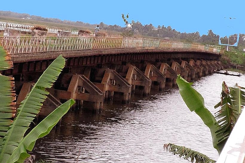
Cotonou-Porto-Novo Canal, Porto Novo, Benin, Africa
The Cotonou-Porto-Novo Canal is an artificial waterway connecting the cities of Cotonou and Porto-Novo in Benin.
It serves as a significant transportation route and ecological feature within the region.
Visual Characteristics
The canal is approximately 10 meters wide and 3 meters deep. Its banks are lined with dense tropical vegetation, including palm trees and various shrubs. The water color is typically a murky brown due to sediment runoff. In some sections, concrete retaining walls are visible.
Location & Access Logistics
The canal runs east-west, connecting the Nokoué Lake near Cotonou to the Aheme Lake near Porto-Novo. Access points are primarily via local roads branching off the RNIE 1 highway. Specific access points include the area near the Cotonou port and various points along the road to Porto-Novo. Parking is generally available along the roadside at designated points, though it can be informal. Public transport options include local taxis and shared minibuses (zemidjans) that traverse the roads adjacent to the canal.
Historical & Ecological Origin
Construction of the canal began in 1927 and was completed in 1930. It was engineered by the French colonial administration with the primary purpose of facilitating trade and transportation between the two major cities, bypassing the need to navigate the open sea. Ecologically, it is an artificial channel that has integrated into the coastal lagoon system, influencing water flow and sediment distribution.
Key Highlights & Activities
Boat travel along the canal is the primary activity, offering transport between communities and for local commerce. Fishing is practiced by residents along the banks. Observation of local birdlife is possible.
Infrastructure & Amenities
Restrooms are not consistently available along the canal's length; facilities are more common in the urban centers of Cotonou and Porto-Novo. Shade is provided by the natural vegetation. Cell phone signal (4G/5G) is generally available in proximity to the urban areas but can be intermittent along more remote stretches. Food vendors are present in the vicinity of the urban access points.
Best Time to Visit
The best time of day for photography is early morning or late afternoon when the sun angle is lower, reducing glare on the water. The dry season, from November to April, offers more predictable weather conditions with less rainfall. There are no specific tide requirements for navigation.
Facts & Legends
A local legend suggests that the canal was dug by a giant serpent in ancient times, though historical records confirm its artificial construction. A practical tip for visitors is to be aware of local fishing nets that may be deployed across sections of the canal.
Nearby Landmarks
- Port of Cotonou (1.5km West)
- Nokoué Lake (0.8km South)
- Porto-Novo Grand Mosque (4.2km East)
- Presidential Palace, Porto-Novo (4.5km East)
- Dantokpa Market, Cotonou (3.0km Southwest)