Information
Landmark: Rønne HarborCity: Bornholm
Country: Denmark
Continent: Europe
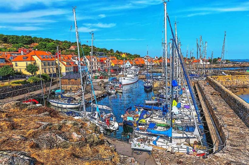
Rønne Harbor, Bornholm, Denmark, Europe
Visual Characteristics
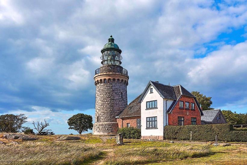
The harbor complex consists of multiple concrete piers, breakwaters, and quays, designed for various vessel types including large passenger ferries, cruise ships, and cargo vessels. Industrial buildings, storage facilities, and ferry terminals line the waterfront. The dominant materials are concrete, steel, and asphalt, with some older stone elements in the original sections. A prominent white lighthouse, the Rønne Lighthouse, marks the harbor entrance. The water within the harbor is characteristic of the Baltic Sea, typically a grey-green hue.
Location & Access Logistics
Rønne Harbor is located on the western edge of Rønne city. It is directly accessible via local roads such as Nordre Kystvej and Søndre Kystvej, which run along the coast. The harbor area is contiguous with the city center, with the main square (Store Torv) approximately 0.7km to the southeast. Ample parking is available in designated areas for ferry passengers and general visitors. The local bus network, operated by BAT, has stops within walking distance of the ferry terminals, connecting the harbor to other parts of Rønne and the island. International ferry services operate from Rønne to Køge (Denmark), Ystad (Sweden), and Sassnitz (Germany).
Historical & Ecological Origin
The development of Rønne Harbor began centuries ago, evolving from a natural bay into a fortified port. Significant expansion and modernization occurred throughout the 19th and 20th centuries to accommodate larger vessels and increased trade volumes. Its original purpose was to facilitate fishing, trade, and provide a strategic naval base. The harbor's current configuration is the result of continuous engineering projects to deepen channels and extend quays, adapting to maritime advancements.
Key Highlights & Activities
Visitors can observe the arrival and departure of large passenger ferries and cargo ships. Walking along the designated pier areas offers views of the working port. Fishing is permitted in specific zones. The harbor serves as the departure point for seasonal boat tours around the coast. The Rønne Lighthouse, located at the harbor entrance, is a notable landmark.
Infrastructure & Amenities
Public restrooms are available within the ferry terminal buildings and at various points in the immediate vicinity. Shade is limited, primarily provided by buildings and structures. Cell phone signal strength is robust, with consistent 4G and 5G coverage throughout the harbor area. Several cafes and kiosks are located near the ferry terminals, and a wider selection of restaurants and shops is available within a 5-minute walk into Rønne city center.
Best Time to Visit
For photography, early morning or late afternoon light provides optimal conditions for capturing the harbor structures and the sea. The months of May through September offer the most favorable weather, with milder temperatures and generally less wind. The Baltic Sea experiences minimal tidal range, so tide levels are not a significant factor for access or activities. Peak activity times coincide with ferry arrival and departure schedules.
Facts & Legends
In May 1945, after Germany's surrender, Rønne and Nexø were bombed by Soviet forces when the German commandant on Bornholm refused to surrender to the Soviets. The harbor sustained damage during these events. A practical tip for visitors is that the best vantage point for viewing the entire harbor, including the lighthouse and incoming ferries, is from the coastal path north of the main port area, near Nørrekås Beach.
Nearby Landmarks
- Rønne Lighthouse: 0.2km West
- Bornholms Museum: 1.0km East
- St. Nicolai Church: 0.8km Southeast
- Erichsens Gård: 0.7km Southeast
- Nørrekås Beach: 1.5km North