Information
City: Santa TeresaCountry: USA New Mexico
Continent: North America
Santa Teresa, USA New Mexico, North America
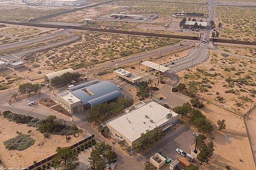
Santa Teresa is a strategic international trade gateway and industrial port of entry situated in the Chihuahuan Desert. It is positioned at the southernmost tip of New Mexico on the United States-Mexico border, immediately adjacent to Santa Teresa, Chihuahua, and 20 km west of El Paso, Texas.
Historical Timeline
Santa Teresa was established as a planned community and industrial hub in the late 20th century, primarily following the 1992 opening of the Santa Teresa Port of Entry. The territory transitioned from ranching land to a logistics epicenter following the North American Free Trade Agreement (NAFTA), which catalyzed the development of the Santa Teresa Intermodal Ramp in 2014. The primary event shaping its current urban form was the massive expansion of the Santa Teresa Industrial Park, designed to bypass the congestion of the El Paso-Juárez urban border crossings.
Demographics & Population
The 2026 estimated population of the Santa Teresa Census Designated Place (CDP) is 5,840. The demographic profile is 78.4% White (primarily identifying as Hispanic) and 18.2% from other races; 86.5% of the total population identifies as Hispanic or Latino. The median age is 34.2 years.
Urban Layout & Key Districts
The community is organized into two distinct functional zones: the Residential Zone (Northwest), featuring suburban housing and country club developments; and the Industrial/Logistics Zone (South), centered on the Port of Entry and the Doña Ana County International Jetport. The Pete Domenici Highway (NM-136) serves as the primary transit spine connecting the border to the interstate system.
Top City Landmarks
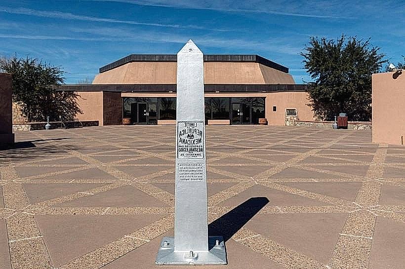
Santa Teresa Port of Entry
War Eagles Air Museum
Santa Teresa Intermodal Ramp (Union Pacific)
Doña Ana County International Jetport
Santa Teresa Country Club
Transportation Network
Internal movement is exclusively dependent on private vehicles; there is no municipal fixed-route bus system. Logistics traffic is dominated by heavy-duty commercial trucks moving between the industrial parks and Mexico. Ride-sharing via Uber and Lyft is available but originates mostly from nearby El Paso or Las Cruces. Traffic density is high at the commercial border crossing but low within the residential sectors.
Safety & "Red Zones"
The general safety level is high due to a heavy presence of U.S. Customs and Border Protection (CBP) and private industrial security. There are no specific "red zones," though visitors should avoid the immediate desert perimeter along the border wall at night. Common scams are minimal, typically restricted to fraudulent freight brokerage or logistics-related identity theft.
Digital & Financial Infrastructure
Average internet speeds reach 1 Gbps via fiber providers such as Comcast (Xfinity) or regional industrial specialists. Main mobile carriers are Verizon, AT&T, and T-Mobile; cross-border signal interference is common. Card acceptance is universal in commercial areas. ATMs are concentrated near the Port of Entry and the Jetport.
Climate & Air Quality
Summers (June–August) are extremely hot and arid, with temperatures frequently reaching 40°C. Winters (December–February) are mild and dry, ranging from -2°C to 15°C. The area is subject to severe sandstorms and high winds in spring. Air quality is generally "Fair," but high levels of wind-blown dust and idling commercial truck emissions near the border often increase particulate matter (PM10).
Culture & Social Norms
Tipping of 18–20% is standard in service establishments. Social norms are heavily influenced by bilingual (English/Spanish) cross-border trade culture. Dress code is either industrial/functional or "desert casual." Smoking is prohibited in public indoor areas. Alcohol regulations are governed by Doña Ana County, with Sunday sales permitted after 11:00 AM.
Accommodation Zones
Airport/Industrial District: Stay here for proximity to the Port of Entry and the Air Museum.
West El Paso (Texas): Most visitors stay 10–15 km east across the state line for a higher density of hotels and retail.
Local Cost Index
Espresso: $4.50
Standard Lunch: $16.00
International Bridge Toll (Car): $3.50
Nearby Day Trips
El Paso, TX (Franklin Mountains): 20 km (20 mins)
Ciudad Juárez, Mexico: 25 km (Border wait times vary)
Las Cruces, NM: 65 km (45 mins)
Mesilla (Historic Plaza): 60 km (40 mins)
Facts & Legends
Santa Teresa is home to one of the few "overweight" border zones in the United States, allowing trucks weighing up to 96,000 lbs to travel between the Mexican border and the industrial parks. A local legend involves "The Giant's Footprint," a geological formation in the nearby desert that early settlers claimed was left by a prehistoric inhabitant. More recently, the area is known for "phantom" GPS signals caused by high-powered radar installations at the nearby Jetport and military testing ranges, which occasionally misdirect cross-country travelers.