Information
Landmark: Cabo de la VelaCity: Santa Marta
Country: Colombia
Continent: South America
Cabo de la Vela, Santa Marta, Colombia, South America
Cabo de la Vela is a coastal promontory located in the La Guajira Department of Colombia. It is a significant geographical and cultural site within the region.
Visual Characteristics
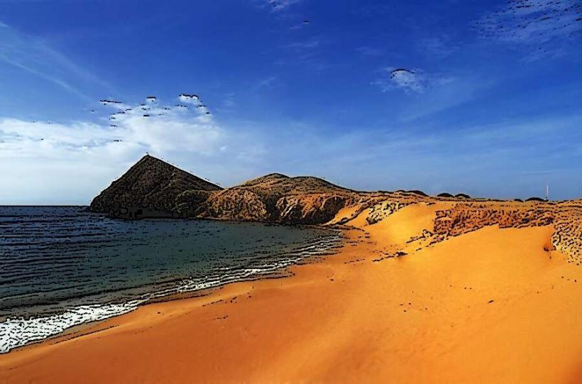
The landscape is characterized by arid, desert-like terrain meeting the Caribbean Sea. Prominent features include large sand dunes, rocky outcrops, and a lighthouse. The sea exhibits varying shades of blue and turquoise. Vegetation is sparse, consisting primarily of drought-resistant shrubs and cacti.
Location & Access Logistics
Cabo de la Vela is situated approximately 150 kilometers east of Riohacha, the capital of La Guajira. Access typically involves a 4x4 vehicle journey from Riohacha, taking approximately 3-4 hours over unpaved roads and sandy tracks. There is no direct public transport. Parking is informal and available near the main settlement areas.
Historical & Ecological Origin
Geologically, Cabo de la Vela is part of the Guajira Peninsula, formed by sedimentary processes and coastal erosion over millennia. It is an important site for the Wayuu indigenous people, who have inhabited the region for centuries and consider it a sacred place.
Key Highlights & Activities
Activities include visiting the Pilon de Azucar rock formation, observing the lighthouse, and experiencing the local Wayuu culture. Swimming is possible in designated areas, though currents can be strong. Kiteboarding and windsurfing are popular due to consistent winds.
Infrastructure & Amenities
Basic infrastructure exists, including a lighthouse operated by the Colombian Navy. Accommodation options are limited to simple cabanas and hammocks offered by local Wayuu families. Food services are available from small, informal eateries serving local seafood. Cell phone signal is intermittent and generally weak.
Best Time to Visit
The dry season, from December to April, offers the most favorable weather conditions with less rain. The best time of day for photography is typically early morning or late afternoon when the light is softer. Wind conditions are generally consistent year-round, making it suitable for water sports.
Facts & Legends
Local Wayuu legends associate Cabo de la Vela with the spirit of a deceased woman, and it is considered a spiritual gateway. The lighthouse, constructed in the early 20th century, serves as a navigational aid for maritime traffic in the area.
Nearby Landmarks
- Punta Gallinas: 60km North (approximate)
- Bahia Honda: 45km Southwest (approximate)
- Manaure Salt Flats: 70km West (approximate)
- Uribia: 80km West (approximate)